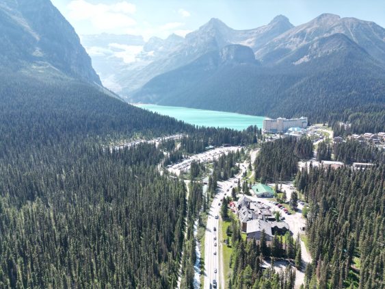
Watson Island Redevelopment Project
Because of the Watson Island Redevelopment Project, the Prince Rupert community has witnessed a new beginning for the site of a former pulp mill.
McElhanney’s in house web mapping platform, Vertisee, was used to host all of the relevant project information including current and historical assets, orthophoto, LiDAR and field crew assessments.
McElhanney deployed Vertisee, its own web-based mapping solution, and developed a tool within it which allowed multiple consultant / subcontractors to submit work simultaneously during the Highway 1 road upgrades.
McElhanney’s GIS system, Vertisee, was used to identify potential land use conflicts and synergies, for a land use plan as part of the implementation of the First Nations Land Management Act for Haisla First Nation.
McElhanney designed and implemented a mobile field program and desktop conversion of various data sources to update Metro Vancouver Regional District’s spatial database of all assets owned and maintained by the Parks department.
The Warman & Martensville Interchanges or Overpasses located on Highway 12 at Martensville and Highway 11 at Warman, will improve safety for two of the fastest growing communities in Saskatchewan.
McElhanney was retained by Progress Energy for the purpose of asset management/inventory. McElhanney split the asset management project into 3 phases; (1) project initiation and development of Vertisee, an online web-based map to sort and file information collected on roads, bridges and other assets; (2) data acquisition and management; and (3) ongoing updates.
The Prince Rupert Gas Transmission Project (PRGTP) is a proposed 900 kilometre natural gas pipeline running from Hudson’s Hope to Lelu Island on the BCs North Coast. This project involved extensive digital data collection in the field using the latest technology and continual updates to Vertisee, McElhanney’s own web-based GIS mapping platform.
FLNRO North Coast Land Use Planning 2012-2014 | Kitimat & Prince Rupert, BC – McElhanney provided GIS and mapping support for the land use development plan for future LNG and industrial developments in the Kitimat and Prince Rupert regions of Northern BC.
High Rockies Trail Completed in 2017, this approximately 80 km portion of the Trans Canada Trail connects the Elk Valley of British Columbia to Banff National Park, and offers breath-taking views of the Rocky Mountains. The Trail accommodates a wide variety of uses (biking, hiking, skiing, etc.) along its length.